


13919796-Les Ressuintes 16.36

togolo28
User
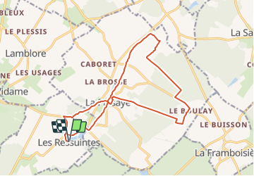

Length
16.4 km

Max alt
248 m

Uphill gradient
131 m
Km-Effort
18.1 km

Min alt
200 m

Downhill gradient
130 m
Boucle
Yes
Creation date :
2021-12-05 13:59:31.654
Updated on :
2021-12-05 14:00:02.493
--
Difficulty : Medium

FREE GPS app for hiking
 SityTrail
IGN / Geographical institutes
SityTrail Plus
The world is yours!
About
Trail Walking of 16.4 km to be discovered at Centre-Loire Valley, Eure-et-Loir, Les Ressuintes. This trail is proposed by togolo28.
Positioning
Country:
France
Region :
Centre-Loire Valley
Department/Province :
Eure-et-Loir
Municipality :
Les Ressuintes
Location:
Unknown
Start:(Dec)
Start:(UTM)
348002 ; 5384550 (31U) N.
Comments